Difference between revisions of "ICT teacher handbook/Your desktop atlas with KGeography"
m (1 revision imported: from troer) |
Latest revision as of 14:31, 28 June 2017
Introduction
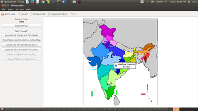
KGeography is a free and open source map software. You can access the political maps of countries and continents. For most maps, you can click on the provinces identified within the map, and KGeography will reveal the name of the province. You can also respond to quizzes on names of provinces, capitals etc. Since KGeography is free and open source, it can be modified by software engineers. This has to be done to show Telangana and Andhra Pradesh in the India map, which currently shows undivided Andhra Pradesh.
The tool helps students to build a visual map of the earth, with the political boundaries of countries within continents. The quizzes may make it interesting for students to explore on their own. The class 6 chapter on reading and making maps can be facilitated with sessions from this section.
Chapter Objectives
- Understanding political maps of regions in the Earth, such as continents, countries, states.
- Becoming familiar with the continents of Europe and Africa using the maps.
- Exploring the political geography of these two continents and the countries in these two continents (Class VII Geography)
- Becoming familiar with the different land forms (peninsula, island etc)
Digital learning resources
- Handout for KGeography
Additional Resources
Level 2 -> 2 weeks
- This activity requires two weeks (2 3 period blocks): 1 period for demonstration, 1 for quiz and 4 periods for the hands-on work.
- In the first demonstration period, you can show the maps of Europe and Africa
- In the two subsequent hands-on periods, students can select the countries in the continents, read their capitals and familiarise themselves. They can also be asked to study the land - water mass in and around both continents.
- In the second demonstration class for 1 period, you can run a quiz for some of the countries of these two continents.
- In the two subsequent hands-on periods, you can ask students to select any one country in either of these continents and do a photo essay of that country. They can take screen shot of the country's map, and write an essay on the country, covering history, bordering countries, geographic features such as climate, soils, seasons, rainfall, natural features, festivals, political systems etc. They can be encouraged to consult others and elders to get information on some of these aspects. Such projects can integrate the social sciences learning for the students. You should encourage the students to take different countries, so that when they present their essays, it would be learning for others. This activity can be done in teams/groups as well.
- Over years, you would be collecting essays on different countries, created by your students. This can become a part of your own resource repository, which you share with subsequent batches of students and encourage them to improve on the same in their efforts. Thus student portfolios can be improved by the same students or by the next batch of students across the years.

