File:India climatic disaster risk map en.svg
Revision as of 04:41, 24 November 2016 by Soumya (talk | contribs) ({{Information |Description ={{en|1=Map showing zones shaded by risk of climate-related natural disaster in India}} |Source =https://commons.wikimedia.org/wiki/File:India_climatic_disaster_risk_map_en.svg |Author =Saravask, based on m...)

Size of this PNG preview of this SVG file: 530 × 599 pixels. Other resolution: 212 × 240 pixels.
Original file (SVG file, nominally 1,639 × 1,852 pixels, file size: 660 KB)
Summary
| Description |
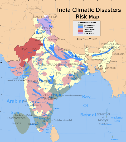
English: Map showing zones shaded by risk of climate-related natural disaster in India
|
| Date | |
| Source | https://commons.wikimedia.org/wiki/File:India_climatic_disaster_risk_map_en.svg |
| Author | Saravask, based on map work by Planemad and Nichalp |
Licensing

|
Permission is granted to copy, distribute and/or modify this document according to the terms in Creative Commons License, Attribution-ShareAlike 4.0. The full text of this license may be found here: CC by-sa 4.0 |
File history
Click on a date/time to view the file as it appeared at that time.
| Date/Time | Thumbnail | Dimensions | User | Comment | |
|---|---|---|---|---|---|
| current | 04:41, 24 November 2016 | | 1,639 × 1,852 (660 KB) | Soumya (talk | contribs) | {{Information |Description ={{en|1=Map showing zones shaded by risk of climate-related natural disaster in India}} |Source =https://commons.wikimedia.org/wiki/File:India_climatic_disaster_risk_map_en.svg |Author =Saravask, based on m... |
You cannot overwrite this file.
File usage
The following file is a duplicate of this file (more details):
- File:India climatic disaster risk map en.svg from Wikimedia Commons
The following 2 pages use this file: