ICT student textbook/Local weather and climate patterns
Objectives
- Exploring the temperature maps and different temperature zones in Marble.
- Hypothesising possible causes for temperature patterns in different regions in the Earth
What prior skills are assumed
- Opening different applications and creating folders and saving files
- Familiarity with using a key board
- Control in using a mouse or track pad
What resources do you need
- Working computer lab with projector
- Computers installed with Ubuntu Operating System
- Handout for Ubuntu
- Handout for Marble
What digital skills will you learn
- Learning to work with interactive applications, with given input
Description of activity with detailed steps
Teacher led activity
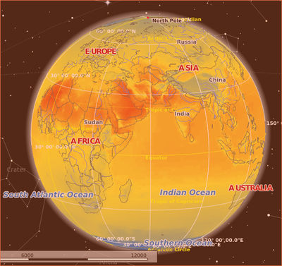
Your teacher will demonstrate the temperature maps and different temperature zones in the Earth. She will discuss possible reasons for the temperature patterns in different regions. She will help you to search for articles from the internet relating to climate change (global warming)
Student activities
- You can see the 'Temperature (July)' and Temperature (December)' maps. In the June map, where is the weather hotter - northern or southern hemisphere? In the northern hemisphere, where is it the hottest? Why? Why is it hotter around the Tropic of Cancer in Africa and West Asia, compared to India?
- In the 'Temperature (December) map, where is the weather hotter - northern or southern hemisphere? Why is the southern hemisphere not as hot in December as the northern hemisphere is in July? In December, the northern hemisphere has larger areas which are colder, compared to Southern hemisphere during July. (or the range of temperatures in northern hemisphere is much more than the southern hemisphere). Why?
- Basically discuss what are the various factor that affect weather/climate - latitude, vegetation/forest area, coastal region v/s hinterland (distance from sea/water body), altitude, land mass vs water body etc). Discuss the weather and climate in your own location / region. What are the causes for the weather / climate patterns? Which countries are more vulnerable to the rising of ocean levels due to global warming?
- How has the weather been in Telangana and India during this year, what are possible causes of the same
- Can you type your answers to these questions in a text document. You can export images from Marble, using Screenshot and insert in the text document along with your explanations.
- Record the summary of the discussions in a text document (this can be done as a group activity)
Portfolio
- Your text document, with your inserted images and explanations
- Your folder of images created and a text document with the picture essay

