ICT student textbook/Playing with the globe
Objectives
- Exploring Earth as a 3-D model and explore different maps provided
What prior skills are assumed
- Opening different applications and creating folders and saving files
- Familiarity with using a key board
- Control in using a mouse or track pad
What resources do you need
- Working computer lab with projector
- Computers installed with Ubuntu Operating System
- Handout for Ubuntu
- Handout for Marble
- Handout for Screenshot
What digital skills will you learn
- Learning to work with interactive applications, with given input
- Creating picture essays on a topic
Description of activity with detailed steps
Teacher led activity
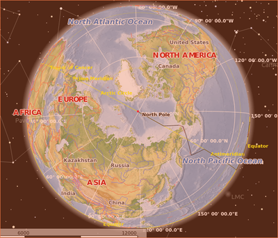
Your teacher will demonstrate Earth as a 3-D model and explore different maps provided. She will zoom into specific regions and move the earth in different directions, to give different views of the Earth.
Student activities
- You can open the "Atlas" map to see the different continents and oceans. You can rotate the Earth to see the entire globe. You can simulate the rotation of the earth by moving the Globe from left (west) to right (east). You can use the mouse to increase the zoom to see a place in more detail. You can move the Atlas to see India and increase the zoom to see the cities and towns in Telangana. Pick up any country of your choice. Try to move the Atlas to locate that region (though you will not see the country name, you can locate the cities and towns, rivers and mountains of that region).
- Chapter 2 of your class 6 text book is 'Globe - a model of the Earth'. Can you relate the activities in that chapter to the Marble globe? Identify the land masses and water masses. Are they equal? Are they equally distributed in the northern and southern hemispheres?
- You can make notes of your observations, analyses and conclusions. You can type these in a text document and insert the relevant images from Marble, captured through Screenshot.
Portfolio
- Your notes of your observations, analyses and conclusions, typed in a text document.
- Screenshots of the maps studied.

