Difference between revisions of "Learn Marble"
| (One intermediate revision by one other user not shown) | |||
| Line 1: | Line 1: | ||
| − | + | ''[http://karnatakaeducation.org.in/KOER/index.php/%E0%B2%AE%E0%B2%BE%E0%B2%B0%E0%B3%8D%E0%B2%AC%E0%B2%B2%E0%B3%8D_%E0%B2%95%E0%B2%B2%E0%B2%BF%E0%B2%AF%E0%B2%BF%E0%B2%B0%E0%B2%BF ಕನ್ನಡದಲ್ಲಿ ನೋಡಿ]'' | |
| − | |||
| − | ''[http://karnatakaeducation.org.in/KOER/index.php/%E0%B2%AE%E0%B2%BE%E0%B2%B0%E0%B3%8D%E0%B2%AC%E0%B2%B2%E0%B3%8D_%E0%B2%95%E0%B2%B2%E0%B2%BF%E0%B2%AF%E0%B2%BF%E0%B2%B0%E0%B2%BF ಕನ್ನಡದಲ್ಲಿ ನೋಡಿ]'' | ||
{{Template:Book-sidebar}} | {{Template:Book-sidebar}} | ||
====Introduction==== | ====Introduction==== | ||
| Line 74: | Line 72: | ||
You can create information for analysing selected topics in Geography. Students can explore the maps for different topics such as | You can create information for analysing selected topics in Geography. Students can explore the maps for different topics such as | ||
#Rainfall patterns in July and December in India (corresponding to South west and North East monsoons), rain shadow regions, and explore causes for different rainfall patterns. | #Rainfall patterns in July and December in India (corresponding to South west and North East monsoons), rain shadow regions, and explore causes for different rainfall patterns. | ||
| − | #Latitudes and longitudes, the role of each and differences between the two. | + | #Latitudes and longitudes, the role of each and differences between the two. (See [http://karnatakaeducation.org.in/KOER/en/index.php/The_Earth-Our_Living_Planet KOER] for resource on this topic) |
===References=== | ===References=== | ||
| Line 80: | Line 78: | ||
[[Category:Explore an application]] | [[Category:Explore an application]] | ||
| + | |} | ||
Latest revision as of 14:24, 11 August 2018

Introduction
Marble is a virtual desktop globe and world atlas, which can be used to learn more about the Earth. You can pan and zoom, click on a label to open a corresponding Wikipedia article, and view the globe and maps with various projections with Marble.
Basic information
| ICT Competency | Marble is a free and open source educational software for subject resource creation.
This tool can be used to teach maps of different regions (physical geography). |
| Educational application and relevance | Atlas is an essential resource for a Geography teacher. An atlas is required to learn political geography as well as physical geography. Marble is a digital atlas. It can be used to understand and analyse map information of the Earth. Lessons can be created using different maps from Marble to understand certain concepts in geography |
| Version | Marble Virtual Globe Version 1.12.20 |
| Configuration | No specific configuration requirements |
| Other similar applications | |
| The application on mobiles and tablets | Marble is not available on mobiles and tablets. |
| Development and community help | 1.Official Website |
Overview of Features
Marble is an virtual atlas, it has many digital maps of the Earth. These maps provide information about physical geography of the Earth, including topography, rainfall, climate etc. It also has ‘historical’ maps which give the information about the Earth at various points in time in the past, relating to political regimes at that time
Installation
- The application is part of the Ubuntu custom distribution.
- In case you do not find it on your computer, you can install by typing
Marbleon top search bar in Software Centre. - If you would like to install through the terminal follow these steps below:
- Open terminal by clicking Applications->System Tools->Terminal or through Keyboard shortcut
Ctrl+Alt+T - In the terminal window, type below command and press enter to start the installation by providing your machine password:
sudo apt-get install marble
- Open terminal by clicking Applications->System Tools->Terminal or through Keyboard shortcut
Working with the application
- Navigating the globe with Marble
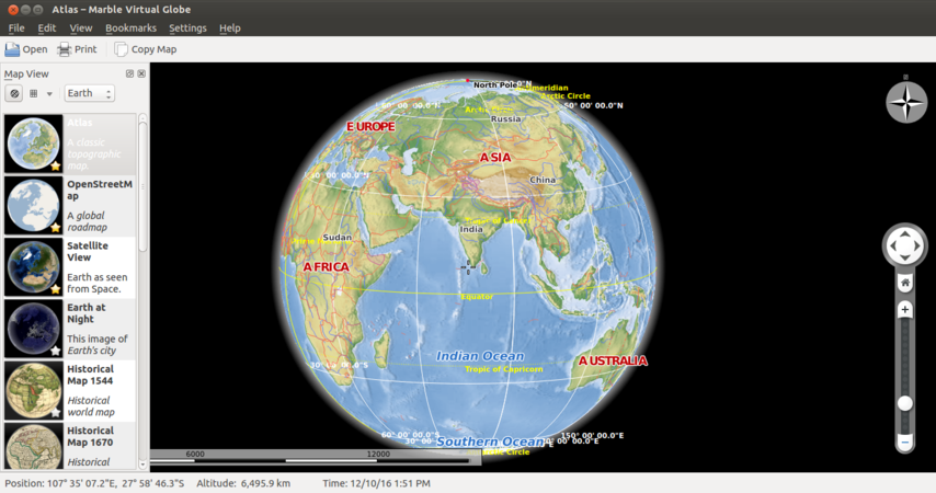
Marble main page
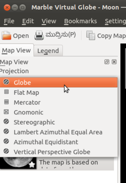
Projection in Marble


- Marble can be opened from Applications → Education → Marble. Once Marble is open you will see a window like this. On left side of your desktop you can see "Map View". In case you do not see the 'Map View' on the left side, you should select 'Settings -> Panels -> Map View' and check it.
- Under Map View you should select "projection" type. Here you will see different projection types. You can choose needed. After this, Below the projection type, there will be option called " Celestial Body. Under this option, you can Moon or Earth or few other planets' view.
Opening and studying maps
- Opening and studying maps
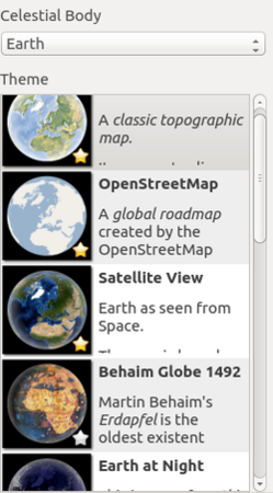
Different maps
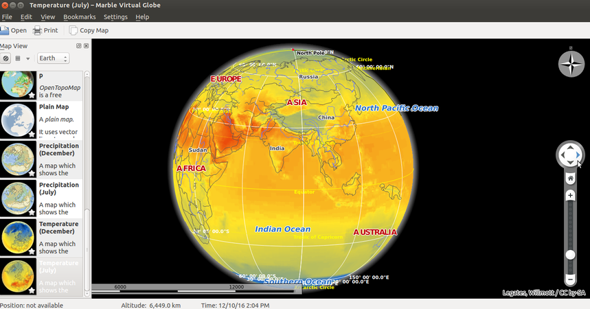
Temperature map


- On the left side you will see many maps one below the other. Selecting any of them, will open it fully on the right side. You can use your mouse to move the Earth in all ways – top to bottom and bottom to top, right to left and left to right. You can click on the map at any place to expand it – this is ‘drilling down’ the map. You can also use the scale bar at the right to increase/reduce the map size and change its orientation.
- For Example : Open the “Temperature July” map. You can study the temperature patterns across the Earth during July on this map. Colour conventions have been used to suggest the temperature during this month. Open each of the maps available in the application.
Saving the files and formats
Marble does not have its own file format, which you can create, edit and save. However you can export images of the maps you are working on.
You can export map and create an image file from Marble through the File – Export Map option.
Advanced features
You can search for locations in Marble. You can configure the physical features you want to see on a Map (you can remove features you do not want to see on a Map)
Ideas for resource creation
You can create information for analysing selected topics in Geography. Students can explore the maps for different topics such as
- Rainfall patterns in July and December in India (corresponding to South west and North East monsoons), rain shadow regions, and explore causes for different rainfall patterns.
- Latitudes and longitudes, the role of each and differences between the two. (See KOER for resource on this topic)
References
Wikipedia |}