Difference between revisions of "Learn KGeography"
Jump to navigation
Jump to search
| (27 intermediate revisions by 5 users not shown) | |||
| Line 1: | Line 1: | ||
| − | + | ''[http://karnatakaeducation.org.in/KOER/index.php/%E0%B2%95%E0%B3%86-%E0%B2%9C%E0%B2%BF%E0%B2%AF%E0%B3%8B%E0%B2%97%E0%B3%8D%E0%B2%B0%E0%B2%BE%E0%B2%AB%E0%B2%BF_%E0%B2%95%E0%B2%B2%E0%B2%BF%E0%B2%AF%E0%B2%BF%E0%B2%B0%E0%B2%BF ಕನ್ನಡದಲ್ಲಿ ನೋಡಿ]'' | |
| − | + | {{Template:Book-sidebar}} | |
| − | == | + | ===Introduction=== |
| − | + | KGeography is a Free and open source educational software game that supports learning in political geography. It is part of the Kde educational project (like other 'K' applications like Kanagram) | |
| − | + | ====Basic information==== | |
| − | |||
| − | |||
| − | |||
| − | |||
| − | |||
| − | |||
| − | |||
| − | |||
| − | |||
| − | |||
| − | K | ||
| − | |||
| − | |||
| − | |||
| − | |||
| − | |||
| − | == | ||
| − | |||
| − | = | ||
| − | == | ||
| − | |||
| − | |||
{| class="wikitable" | {| class="wikitable" | ||
|- | |- | ||
| − | | | + | |ICT Competency |
| − | | | + | |KGeography is a Free and open source educational software for subject resource creation. (political geography) |
|- | |- | ||
| − | | | + | |Educational application and relevance |
| − | + | |Atlas is an essential resource for a Geography teacher. An atlas is required to learn political geography as well as physical geography. KGeography is a digital atlas that provides maps of continents, countries and states (political geography). Simple quizzes are available in KGeography to test understanding / memory of different regions. | |
| − | |||
| − | |||
| − | |||
| − | |||
|- | |- | ||
| − | | | + | |Version |
| − | | | + | |Version 0.9 |
|- | |- | ||
| − | | | + | |Configuration |
| − | | | + | |No specific configuration requirements. |
| + | |- | ||
| + | |Other similar applications | ||
| + | | | ||
| + | *[https://marble.kde.org/ Marble] | ||
| + | *Non free digital atlas includes: [https://www.google.com/earth Google Earth] and [http://bhuvan.nrsc.gov.in/bhuvan_links.php Bhuvan] (ISRO). | ||
| + | |- | ||
| + | |The application on mobiles and tablets | ||
| + | |KGeography is not available on mobiles and tablets. There are Apps available on the Android, for physical and political geography of the Earth . For example, Google Earth and Globe Master apps. | ||
| + | |- | ||
| + | |Development and community help | ||
| + | | | ||
| + | * [https://docs.kde.org/stable5/en/kdeedu/kgeography/index.html User manual for KGeography] | ||
| + | * [https://docs.kde.org/stable5/en/kdeedu/kgeography/index.html User Based Support] | ||
| + | * [https://docs.kde.org/stable5/en/kdeedu/kgeography/index.html Official Website] | ||
|} | |} | ||
| − | == | + | ====Overview of Features==== |
| + | #KGeography is an virtual atlas, it has many digital maps of different political regions in the Earth, such as continents, countries, states. | ||
| + | #As a digital atlas, KGeography allows zoom in and out on a map. You can click the Zoom button and then draw a rectangle to zoom in a part of the map. While in zoom mode, you can press right mouse button to go back to the original map size (the Original Size action has the same effect). You can use the scroll bars, the arrow keys or the mouse wheel to move around the zoomed map or use the Move action that will allow you to drag the map using left mouse button. The Automatic Zoom feature will make the map as big as possible. | ||
| − | |||
| − | == | + | ====Installation==== |
| + | #The application is part of the Ubuntu custom distribution. | ||
| + | #In case you do not find it on your computer, you can install by typing <code>KGeography</code> on top search bar in Software Centre. | ||
| + | #If you would like to install through the terminal follow these steps below: | ||
| + | ##Open terminal by clicking Applications->System Tools->Terminal or through Keyboard shortcut <code>Ctrl+Alt+T</code> | ||
| + | ##In the terminal window, type below command and press enter to start the installation by providing your machine password: | ||
| + | ##<code>sudo apt-get install kgeography</code> | ||
| − | == | + | ===Working with the application=== |
| − | = | + | ==== Navigating KGeography ==== |
| − | + | <gallery mode="packed" heights="250px" caption="Navigating KGeography"> | |
| − | | | + | File:KGeography-Africa_Map.png|KGeography Map |
| − | + | File:KGeography 1 Map of undivided Andhra Pradesh.png|Andtapradesh Map | |
| − | + | </gallery> | |
| − | + | #KGeography can be opened from Applications → Education → KGeography.When you open KGeography, you will see the last map that was opened. The map above is the map of Africa continent. | |
| − | + | #To explore places, Click on "Open Map". Here we opened Andhra Pradesh map. You can use the Filter Maps text field, to quickly get your desired map. Just enter a few first letters of the map name to narrow down the list to a few matches. <br>You will see an old / obsolete map of undivided Andhra Pradesh. (Since KGeography is a free software, the partition of Andhra Pradesh, as well as the creation of new districts in Telangana can be submitted by anybody and the software community managing this application will make the change, following a due process. This is not yet completed) | |
| − | | | + | |
| − | | | + | ==== Quizzes in KGeography ==== |
| − | + | <gallery mode="packed" heights="200px" caption="Quizzes in KGeography"> | |
| − | + | File:option kegeography.png|Types of Quizzes | |
| − | + | File:Quiz Questions in Kgeography.png|Set No of Questions | |
| − | + | File:KGeography 2 Placing districts on the map.png|Placing Districts | |
| − | + | File:Correct Answer in Kgeography.png|Quiz Result with correct and wrong answers | |
| + | </gallery> | ||
| + | #You can then choose what type of learning or quizzing you want to do by looking at the menu on the left. | ||
| + | #KGeography has a set of quiz questions, to test your knowledge of places. In the image, the ‘Place district in the map’ quiz is chosen. You need to place the district map within the state map. you will first asked how many questions you want. Then you will asked to click on a specific districts. | ||
| + | #The cursor takes the shape of a districts and you have to place it in the map. Then you will asked to click on a specific districts. The cursor takes the shape of a districts and you have to place it in the map. | ||
| + | #The results will display when the test is finished. You an see your correct and wrong answers. | ||
| + | |||
| + | ==== Saving the files and formats ==== | ||
| + | KGeography does not have its own file format, which you can create, edit, save and export . However you can create image files of the maps you are working on, by using the [[Learn Screenshot|Screenshot]] application. | ||
| + | |||
| + | ====Advanced features==== | ||
| + | ===Ideas for resource creation=== | ||
| + | You can use the quiz’s in KGeography as a resource for testing. | ||
| − | = | + | ===References=== |
| + | [https://en.wikipedia.org/wiki/KGeography Wikipedia] | ||
| − | + | [[Category:Explore an application]] | |
| − | + | [[Category:Geography]] | |
| − | |||
Latest revision as of 14:25, 11 August 2018

Introduction
KGeography is a Free and open source educational software game that supports learning in political geography. It is part of the Kde educational project (like other 'K' applications like Kanagram)
Basic information
| ICT Competency | KGeography is a Free and open source educational software for subject resource creation. (political geography) |
| Educational application and relevance | Atlas is an essential resource for a Geography teacher. An atlas is required to learn political geography as well as physical geography. KGeography is a digital atlas that provides maps of continents, countries and states (political geography). Simple quizzes are available in KGeography to test understanding / memory of different regions. |
| Version | Version 0.9 |
| Configuration | No specific configuration requirements. |
| Other similar applications |
|
| The application on mobiles and tablets | KGeography is not available on mobiles and tablets. There are Apps available on the Android, for physical and political geography of the Earth . For example, Google Earth and Globe Master apps. |
| Development and community help |
Overview of Features
- KGeography is an virtual atlas, it has many digital maps of different political regions in the Earth, such as continents, countries, states.
- As a digital atlas, KGeography allows zoom in and out on a map. You can click the Zoom button and then draw a rectangle to zoom in a part of the map. While in zoom mode, you can press right mouse button to go back to the original map size (the Original Size action has the same effect). You can use the scroll bars, the arrow keys or the mouse wheel to move around the zoomed map or use the Move action that will allow you to drag the map using left mouse button. The Automatic Zoom feature will make the map as big as possible.
Installation
- The application is part of the Ubuntu custom distribution.
- In case you do not find it on your computer, you can install by typing
KGeographyon top search bar in Software Centre. - If you would like to install through the terminal follow these steps below:
- Open terminal by clicking Applications->System Tools->Terminal or through Keyboard shortcut
Ctrl+Alt+T - In the terminal window, type below command and press enter to start the installation by providing your machine password:
sudo apt-get install kgeography
- Open terminal by clicking Applications->System Tools->Terminal or through Keyboard shortcut
Working with the application
- Navigating KGeography

KGeography Map
Andtapradesh Map


- KGeography can be opened from Applications → Education → KGeography.When you open KGeography, you will see the last map that was opened. The map above is the map of Africa continent.
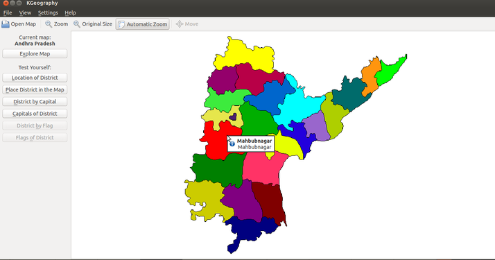
- To explore places, Click on "Open Map". Here we opened Andhra Pradesh map. You can use the Filter Maps text field, to quickly get your desired map. Just enter a few first letters of the map name to narrow down the list to a few matches.
You will see an old / obsolete map of undivided Andhra Pradesh. (Since KGeography is a free software, the partition of Andhra Pradesh, as well as the creation of new districts in Telangana can be submitted by anybody and the software community managing this application will make the change, following a due process. This is not yet completed)
Quizzes in KGeography
- Quizzes in KGeography
Types of Quizzes
Set No of Questions
Placing Districts
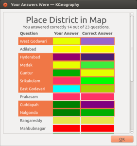
Quiz Result with correct and wrong answers


- You can then choose what type of learning or quizzing you want to do by looking at the menu on the left.
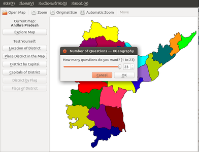
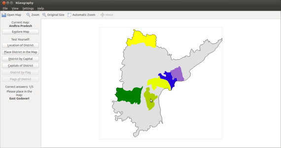
- KGeography has a set of quiz questions, to test your knowledge of places. In the image, the ‘Place district in the map’ quiz is chosen. You need to place the district map within the state map. you will first asked how many questions you want. Then you will asked to click on a specific districts.
- The cursor takes the shape of a districts and you have to place it in the map. Then you will asked to click on a specific districts. The cursor takes the shape of a districts and you have to place it in the map.
- The results will display when the test is finished. You an see your correct and wrong answers.
Saving the files and formats
KGeography does not have its own file format, which you can create, edit, save and export . However you can create image files of the maps you are working on, by using the Screenshot application.
Advanced features
Ideas for resource creation
You can use the quiz’s in KGeography as a resource for testing.