Difference between revisions of "Learn KGeography"
| Line 1: | Line 1: | ||
| − | + | {{Template:Book-sidebar}} | |
=Introduction= | =Introduction= | ||
==ICT Competency== | ==ICT Competency== | ||
Revision as of 12:15, 13 October 2016
Introduction
ICT Competency
Subject (Geography) resource creation.
Educational application and relevance
Atlas is an essential resource for a Geography teacher. An atlas is required to learn political geography as well as physical geography. K Geography is a digital atlas that provides maps of continents, countries and states (political geography). Simple quizzes are available in K Geography to test understanding / memory of different regions.
Version
K Geography Version 0.8.2
Configuration
This tool has no specific configuration requirements
Overview of Features
K Geography is an virtual atlas, it has many digital maps of different political regions in the Earth, such as continents, countries, states.
Other similar applications
Other free digital atlas applications include Marble (physical geograpy_ Non free digital atlas includes https://www.google.com/earth (Google), Bhuvan http://bhuvan.nrsc.gov.in/bhuvan_links.php (ISRO).
Development and community help
- User manual for K Geography is available on https://docs.kde.org/stable5/en/kdeedu/kgeography/index.html
- Community forum could not be located
Working with the application
Functionalities
Overview of the K Geography tool K Geography is part of the Ubuntu distribution. This can be opened from Applications → Education → K Geography.
 Image Image
|
 Image Image
|
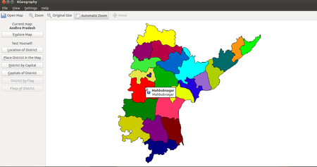
| Step 1 - On the menu, you will see “Open map”. You can select any continent/country/state to open map of that place.
Open the “Andhra Pradesh” map. You can click on ‘Automatic Zoom’ in the menu to expand or contract it. You will see an old / obsolete map of undivided Andhra Pradesh. (Since K Geography is a free software, the partition of Andhra Pradesh, as well as the creation of new districts in Telangana can be submitted by anybody and the software community that is managing this application will make the change, following a due process. |
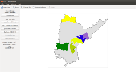
Step 2 - K Geography has a set of quiz questions, to test your knowledge of places.
In the image, the ‘Place district in the map’ quiz is chosen. You need to place the district map within the state map. |
File formats for creation
Saving the file
K Geography does not have its own file format, which you can create, edit and save. However you can create image files of the maps you are working on, by using the screenshot application.
Export and publishing files
You can create an image file from K Geography through the using the screenshot application.
Advanced features
Installation
| Method of installation | Steps |
|---|---|
| From Ubuntu software Centre | Steps |
| From Terminal | Steps |
| From the web | Steps |
| Web based registration | Steps |
The application on mobiles and tablets
K Geography is not available on mobiles and tablets. There are apps available for Android, for physical and political geography of the Earth
Ideas for resource creation
You can use the quizes in K Geography.
