चित्र:Political map of India EN.svg


|
This file may be updated to reflect new information. If you wish to use a specific version of the file without new updates being mirrored, please upload the required version as a separate file. |

सारांश
Administrative divisions
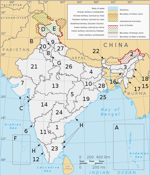
India comprises 28 states and 8 union territories. All states and territories, including the three union territories of Jammu and Kashmir, the National Capital Territory of Delhi and Puducherry have elected legislatures and governments patterned on the Westminster system. The other six union territories are directly ruled by the Centre through appointed administrators. In 1956, under the States Reorganisation Act, states were formed on a linguistic basis.[1] (See also: Political integration of India.) Since then, this structure has remained largely unchanged. Each state or union territory is further divided into administrative districts.[2] The districts in turn are further divided into tehsils and eventually into villages.
States:
Union territories:
References
- ↑ States Reorganisation Act, 1956. Constitution of India. Commonwealth Legal Information Institute. Retrieved on 31 October 2007.
- ↑ Districts of India. Government of India. National Informatics Centre (NIC). Retrieved on 25 November 2007.
लाइसेंस
- आप खुलकर:
- बाँट सकते हैं – रचना की प्रतिलिपि बना सकते हैं, बाँँट सकते हैं और संचारित कर सकते हैं
- रीमिक्स कर सकते हैं – कार्य को अनुकूलित कर सकते हैं
- निम्नलिखित शर्तों के अंतर्गत:
- श्रेय – यह अनिवार्य है कि आप यथोचित श्रेय प्रदान करें, लाइसेंस की कड़ी प्रदान करें, और अगर कोई बदलाव हुए हों तो उन्हें इंगित करें। आप ऐसा किसी भी उचित तरीके से कर सकते हैं, लेकिन किसी भी तरह उससे यह नहीं संकेत नहीं किया जाना चाहिए कि लाइसेंसधारी द्वारा आपको अथवा आपके इस प्रयोग का समर्थन किया जा रहा हो।
- समानसांझा – अगर आप इस रचना में कोई बदलाव करते हैं या इसपर आधारित कुछ रचित करते हैं तो आप अपने योगदान को सिर्फ इसी या इसके सामान किसी लाइसेंस के अंतर्गत बाँट सकते हैं।
फ़ाइल का इतिहास
फ़ाइल पुराने समय में कैसी दिखती थी यह जानने के लिए वांछित दिनांक/समय पर क्लिक करें।
| दिनांक/समय | अंगूठाकार प्रारूप | आकार | सदस्य | टिप्पणी | |
|---|---|---|---|---|---|
| वर्तमान | १३:४९, २८ सितम्बर २०२२ | | १,५९४ × १,८६८ (३२५ KB) | ऐक्टिवेटेड् | File uploaded using svgtranslate tool (https://svgtranslate.toolforge.org/). Added translation for sa. |
फ़ाइल का उपयोग
इस फ़ाइल से कोई पृष्ठ नहीं जुड़ते हैं।